Interestingly, the name Hudhud for the cyclone was born in Oman unlike the cyclone itself which originated in the north Andaman sea in the Bay of Bengal and is now hurtling towards Andhra Pradesh and Odisha states.
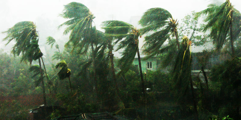
With Cyclone Hudhud expected to make a landfall near Visakhapatnam around noon, the coastal areas of Andhra Pradesh and Odisha have been evacuated by their respective state governments.
The Indian Express reported: On Saturday afternoon, Hudhud was located about 250 km southeast of Visakhapatnam and 340 km south-southeast of Gopalpur, on its way to reach the coast around 12 noon on Sunday.
The cyclone has been classified as “severe” by the Indian Meteorological Department, and which will be “very severe” for six hours after it makes landfall in the area.
The cyclone will move northwestwards across south interior Orissa and Chhattisgarh. Heavy rainfall and a change in the weather is expected at most places in south Chhattisgarh, Telangana and south Orissa during this time.
The IE reported: In Andhra Pradesh, nearly 2.75 lakh people from the four districts of Visakhapatnam, Vizianagaram, Srikakulam and East Godavari were evacuated to about 400 cyclone shelters. About 1.90 lakh people were evacuated from Srikakulam district alone, where the maximum number of people live close to the shore.
It should be noted that the Odisha government had always been a victim of series of cyclones falling in the state. But like last year’s Phailin cuclone, the Odisha government has set itself a target of zero casualty for Hudhud. Around 4 lakh people in the five southern districts of the state that come within the arc of the storm have been evacuated.
Interestingly, the name Hudhud for the cyclone was born in Oman unlike the cyclone itself which originated in the north Andaman sea in the Bay of Bengal and is now hurtling towards Andhra Pradesh and Odisha states.
The name Hudhud in Arabic refers to the Hoopoe bird. The Hudhud, or hoopoe bird, is an exotic creature which has a very distinctive crown of feathers and is widespread in Europe, Asia and North Africa.
According to BBC, the naming of cyclone originating in the North Indian Ocean were anonymous affair. The practice started only recently. It puts the reason as ethnic diversity which required the nomenclature to be neutral so that it does not hurt people’s sentiment.
In 2002, an international panel set up by World Meteorological Organisation was set up and the names were decided upon. Eight countries – India, Pakistan, Bangladesh, Maldives, Myanmar, Oman, Sri Lanka and Thailand – took part. They came up with a list of 64 names – eight names from each country – for upcoming cyclones.
Most of the names for very ferocious cyclones are feminine, like Katrina for example whch hit Indian coasts in the past.
The list goes alphabetically, according to each country. Last year’s Phailin cyclone that hit India’s south-eastern coast was provided by Thailand. Some of the Indian names in the queue are the more prosaic Megh (Cloud), Sagar (Ocean) and Vayu (Wind). The last cyclone in the region was Nanauk in June, a name contributed by Myanmar.
Next time a cyclone hits the region, it’s Pakistan’s turn to give it a name. It will be called Nilofar.